C3 Metals Identifies Multiple Coincident Magnetic and Gravity Anomalies to Drill at Its Khaleesi Project, Peru
Newsfile
September 17, 2026 11:00AM GMT
Toronto, Ontario--(Newsfile Corp. - September 17, 2026) - C3 Metals Inc. (TSXV: CCCM) (OTCQB: CUAUF) ("C3 Metals" or the "Company") is pleased to announce that its geophysics contractor has completed the new drone magnetic and gravity surveys at its 100%-owned Khaleesi copper project ("Khaleesi" or "the Project") in southern Peru (see press release dated June 24, 2026).
High-resolution unmanned aerial vehicle (UAV) drone magnetometer and gravity geophysical surveys were initially planned over 900 hectares. Due to the success of the new surveys in identifying multiple coincident magnetic and gravity anomalies, the Company has expanded the surveys by over 65% to 1,500 hectares. Figure 1 shows the initial 900-hectare survey results, and Figure 4 shows the additional 600 hectares where the expanded surveys are underway.
Dan Symons, President and CEO, stated, "To date, the combination of magnetics and gravity has proven extremely valuable at targeting copper mineralization hosted in magnetite skarns that sit below a thin layer of glacial till cover. We embarked on these additional geophysics programs specifically to identify other potential magnetite skarns over a much broader area. This broader survey area generally corresponds to a modified environmental drill permit that we anticipate obtaining during Q4. This new data shows impressive, sizeable anomalies. Drilling is continuing to expand on the known mineralized zone at Khaleesi with a goal of beginning to drill test newly identified targets in Q4."
Khaleesi Geophysical Survey Highlights
- A new geophysical survey identified coincident and large-scale magnetic and gravity anomalies beneath the glacial till cover at Khaleesi. Large anomalies are present where recent drilling intersected broad zones of intrusive and skarn hosted copper-gold-molybdenum mineralization (see press releases dated February 26, 2026, April 29, 2026, June 26, 2026 and September 15, 2026).
- A drone magnetics survey comprised 40 line-kilometres with 50m line spacings. A gravity survey comprised 900 hectares with data collected at 100m spacings. Results include:
- Multiple northeast-southwest trending coincident magnetic and gravity anomalies that are coincident with the intrusive complex - Ferrobamba Formation contact zone that hosts the copper-gold-molybdenum mineralization (Figure 1).
- The main skarn zone at Khaleesi correlates well with a strong coincident magnetic and gravity anomaly that measures 500m by 600m. The anomaly extends to the northeast (Figures 1 and 2).
- A second and potentially larger magnetic and gravity anomaly is partially defined approximately 2km northeast of the Khaleesi main skarn. Recent geological mapping confirms a large-scale magnetite skarn in the area (see Figures 1, 2, and 3).
- The drone magnetic and gravity surveys have been expanded and are currently underway in the northeast project area with the goal of capturing the extent of this new, large-scale coincident magnetic and gravity anomaly. Geological mapping confirms the presence of magnetite skarn associated with the anomaly (Figures 3 and 4).
- Cross sections through the 3D magnetic inversion model A-A' and the gravity inversion model B-B' demonstrates the two large scale and deep-rooted magnetic anomalies, including the new prospect to the northeast (Figure 2).
- Multiple new coincident magnetic and gravity anomalies have been identified to the southwest, south and southeast.
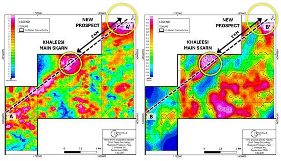
Figure 1. (Left) Drone magnetic plan view showing multiple magnetic anomalies along a northeast-southwest trend and additional new anomalies to the south. (Right) Gravity image showing multiple gravity anomalies along the same northeast-southwest trend and additional new anomalies to the south.
To view an enhanced version of this graphic, please visit:
https://images.newsfilecorp.com/files/2661/314731_eacc83a854b619ae_001full.jpg
Survey Details
The recently completed drone magnetic and gravity surveys have proven to be an excellent exploration tool to identify blind skarn targets in the project area, which is predominantly covered by a thin layer of glacial till. The data has provided high-resolution magnetic and gravity information that has been inverted to produce 3D block models for each dataset. The block models show geological and structural patterns beneath the 5-50m thick glacial till cover. The anomalies predominantly follow a northeast-southwest trend. This trend is similarly identified and modeled using existing drill data that define zones of copper-gold-molybdenum mineralization. Drill core magnetic susceptibility and specific gravity measurements confirm the model, increasing confidence of the geophysical datasets.
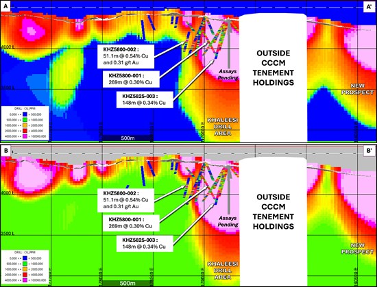
Figure 2. (Top) Cross section through the 3D magnetic inversion model A-A' shows the two large scale and deep-rooted magnetic anomalies at the main Khaleesi drill area and a new prospect approximately 2km to the northeast. (Bottom) Cross section through the 3D gravity inversion model B-B' shows the two large scale and deep-rooted gravity anomalies at main Khaleesi drill area and a new prospect approximately 2km to the northeast.
To view an enhanced version of this graphic, please visit:
https://images.newsfilecorp.com/files/2661/314731_eacc83a854b619ae_002full.jpg
The 3D magnetic and gravity inversion models show large scale coincident magnetic and gravity anomalies at Khaleesi and at a new prospect 2km to the northeast. The new prospect has outcropping skarn that has been mapped over a 200m by 150m area (Figure 3). The skarn is characterized by massive magnetite replacing dolomite of the Ferrobamba Formation. The partially defined magnetic anomaly near to the new prospect appears to be larger or of similar scale to the magnetic anomaly covering the main Khaleesi skarn zone. This warranted extending the geophysical surveys to cover the new prospect area (Figure 4).
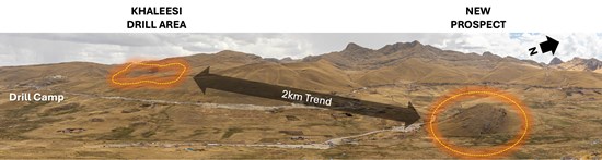
Figure 3: Panorama image showing the Khaleesi Project and the new prospect 2km to the northeast. Geologic mapping has confirmed the presence of magnetite skarn associated with a new, large-scale coincident magnetic and gravity high.
To view an enhanced version of this graphic, please visit:
https://images.newsfilecorp.com/files/2661/314731_eacc83a854b619ae_003full.jpg
Next Steps
Drilling at Khaleesi has intersected broad zones of intrusive and skarn hosted copper-gold-molybdenum mineralization that remains open to the north, east and west (see press releases dated February 26, 2026, April 29, 2026, June 26, 2026 and September 15, 2026).
Magnetic and gravity datasets have increased targeting confidence by enabling the Company to focus future drilling on testing the northeast-southwest trending mineralized skarn and intrusive complex. This could potentially extend 2km from the original Khaleesi discovery to the new prospect. An amended environmental drill permit (modified DIA) is anticipated in Q4 (Figure 4).
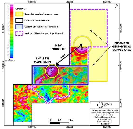
Figure 4. Drone magnetic image over the Khaleesi Project showing the expanded area for the ongoing geophysical surveys in yellow. Note the blue border and the purple dotted border outlines, which represent the current drill permitted area and the modified drill permit area, respectively.
To view an enhanced version of this graphic, please visit:
https://images.newsfilecorp.com/files/2661/314731_eacc83a854b619ae_004full.jpg
Additionally, surface mapping and soil sampling continues across the broader Khaleesi project area and is expected to be completed in Q4. The Company continues drill testing additional skarn targets and expanding on the known skarn and diorite hosted mineralization. Geometallurgical work is also being planned to identify extraction methods and recoveries for copper, gold, silver, molybdenum and iron.
The Company looks forward to reporting additional geophysical survey and assay results as they become available.
About the Khaleesi Project
The Khaleesi project is located in the Andahuaylas-Yauri Belt in southeastern Peru, home to large copper skarn and porphyry deposits and operating mines such as Las Bambas (MMG), Constancia (Hudbay Minerals), Antapaccay (Glencore), and others (Figure 5).
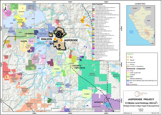
Figure 5: Regional map showing C3 Metals' mineral concession package in relation to other large-scale operations, development projects and exploration projects.
To view an enhanced version of this graphic, please visit:
https://images.newsfilecorp.com/files/2661/314731_eacc83a854b619ae_005full.jpg
Khaleesi is located 8km west of the Company's Jasperoide Project, where the Company confirmed 13 skarn prospects along a 28km iron-skarn belt. Montana de Cobre ("MCZ") is the only skarn along the 28km iron-skarn belt that the Company has systematically drill tested to date, yielding a near surface Measured and Indicated Mineral Resource of 51.9 million tonnes at 0.50% total copper and 0.20 g/t gold for 569.1 million pounds of copper and 326,800 ounces of gold.1
The Khaleesi project is situated along a highly favorable limestone-intrusive rock contact zone that bisects the tenement area and trends north-northeasterly. The limestone rock unit is part of the highly receptive Ferrobama Formation, and the intrusive rock comprises the well-known Andahuaylas-Yauri Batholith. At this contact zone is a multiphase intrusive complex that also appears to trend northeast-southwest, that follows and exploits the contact zone, which is mostly covered by a thin layer of glacial till.
For additional information, contact:
Dan Symons
President and CEO
+1 416 716 6466
[email protected]
ABOUT C3 METALS INC.
C3 Metals Inc. is a mineral exploration company focused on creating substantive value for its shareholders through the discovery and development of large copper and gold deposits. The Company holds approximately 31,000 hectares located in the prolific high-grade Andahuaylas-Yauri Porphyry-Skarn belt of Southern Peru, which contain the Company's Jasperoide and Khaleesi projects. Mineralization at Jasperoide is hosted in a similar geological setting to the nearby major mining operations at Las Bambas (MMG), Constancia (Hudbay) and Antapaccay (Glencore). At Jasperoide, the Company has identified over 13 skarn prospects and an outcropping porphyry system over two parallel 28km belts. The Company has published a maiden resource estimate on the first of these skarn targets, which contained Measured & Indicated Resources of 52Mt at 0.5% copper and 0.2 g/t gold1. The Company is also actively exploring in Jamaica where it has identified 16 porphyry, 40 epithermal and multiple volcanic redbed copper prospects over a 30km strike extent. The Company holds a 100% interest in 17,855 hectares of exploration licenses, of which Freeport-McMoRan Exploration Corporation, a wholly-owned affiliate of Freeport-McMoRan Inc. (NYSE: FCX), has the option on 13,020 hectares to earn up to a 75% interest by funding up to US$75 million of exploration and project related expenditures. The Company also holds a 50% interest in 9,870 hectares in a joint venture with Geophsyx Jamaica Ltd, the largest mineral tenure holder in the country. Barrick Mining Corp. announced on May 1, 2024 that it had entered into an earn-in agreement with Geophysx Jamaica Ltd. on approximately 400,000 hectares of exploration licenses, several of which surround C3 Metals' mineral concessions. Mining is currently the second largest industry in Jamaica, and historical mining dates back to the colonial eras of the 1500s (Spanish) and 1800s (British).
Related Link: www.c3metals.com
Neither the TSX Venture Exchange nor its Regulation Services Provider (as that term is defined in the policies of the TSX Venture Exchange) accepts responsibility for the adequacy or accuracy of this release.
QP Statement
Stephen Hughes, P.Geo. is Vice President Exploration and a Director for C3 Metals and is a Qualified Person as defined by National Instrument 43-101. Mr. Hughes has reviewed the technical information in this news release and approves the written disclosure contained herein.
Caution Regarding Forward-Looking Statements
Certain statements contained in this press release constitute forward-looking information. These statements relate to future events or future performance. The use of any of the words "could", "intend", "expect", "believe", "will", "projected", "estimated" and similar expressions and statements relating to matters that are not historical facts are intended to identify forward-looking information and are based on the Company's current belief or assumptions as to the outcome and timing of such future events. Actual future results may differ materially. Although such statements are based on reasonable assumptions of the Company's management, there can be no assurance that any conclusions or forecasts will prove to be accurate.
While the Company considers these assumptions to be reasonable based on information currently available, they may prove to be incorrect. Forward looking information involves known and unknown risks, uncertainties and other factors which may cause the actual results, performance or achievements to be materially different from any future results, performance or achievements expressed or implied by the forward-looking information. Such factors include risks inherent in the exploration and development of mineral deposits, including risks relating to changes in project parameters as plans continue to be redefined, risks relating to variations in grade or recovery rates, risks relating to changes in mineral prices and the worldwide demand for and supply of minerals, risks related to increased competition and current global financial conditions, access and supply risks, reliance on key personnel, operational risks, and regulatory risks, including risks relating to the acquisition of the necessary licenses and permits, financing, capitalization and liquidity risks.
The forward-looking information contained in this release is made as of the date hereof, and the Company is not obligated to update or revise any forward-looking information, whether as a result of new information, future events or otherwise, except as required by applicable securities laws. Because of the risks, uncertainties and assumptions contained herein, investors should not place undue reliance on forward-looking information. The foregoing statements expressly qualify any forward-looking information contained herein.
1 Based on the assumptions and parameters outlined in the NI 43-101 Technical Report titled Jasperoide Copper-Gold Project Cusco Region, Peru dated July 5, 2023.

To view the source version of this press release, please visit https://www.newsfilecorp.com/release/314731
