Geomorphic AI Offers Riikonkoski Copper-Gold Project in Finland for Joint Venture - Historic Copper System Shows High-Grade Gold Potential and Remains Open at Depth
Newsfile
August 20, 2026 4:57PM GMT
Portland, Oregon and Helsinki, Finland--(Newsfile Corp. - August 20, 2026) - Geomorphic AI ("Geomorphic" or the "Company"), an AI-driven minerals prospect generator, is pleased to announce that it has completed a new archive compilation and digital reconstruction of the Riikonkoski Copper-Gold Project ("Riikonkoski" or the "Project") in Finland's Central Lapland Greenstone Belt.
The work highlights a compelling opportunity to re-evaluate a historic copper system for gold. The Geological Survey of Finland ("GTK") completed 110 drill holes totaling approximately 22,162 metres across Riikonkoski and its satellite prospects between 1969 and 1974, defining five copper zones. However, historic exploration was overwhelmingly focused on copper, with less than 5% of the drilled metreage ever assayed for gold.
Subsequent re-assaying of stored GTK core and pulps returned individual gold samples grading up to 39.0 g/t Au and 28.9 g/t Au, while historic composite intervals reported by Taranis Resources include 6.0 metres at 6.75 g/t Au and 0.48% Cu and 6.0 metres at 5.69 g/t Au and 1.38% Cu.
Geomorphic holds the 6,087-hectare Project through granted mineral reservation VA2026:0034 and is making Riikonkoski available for joint venture, earn-in or sale.
No modern drilling has been completed at the Project and no hole has tested the system below approximately 400 metres.
Geomorphic AI VP of Business Development, Jeff Phillips said: "Riikonkoski is a 1970s copper discovery inside one of Europe's most active gold districts, but it was never subjected to a gold-first exploration programme. Less than a twentieth of the historic drilling was assayed for gold, and nearly every significant gold sample we recovered occurs within the existing copper system. That gives a partner a very clear starting point: re-assay the untested historic core, verify the strongest stored-core intervals and drill beneath a system where copper remains above 1% within 40 metres of the deepest hole ever drilled. The system has already been found - the gold question and the depth question are still open."
PROJECT HIGHLIGHTS
- Drilled copper system with historical scale
GTK completed 110 historic drill holes totaling approximately 22,162 metres across Riikonkoski and its satellite prospects. Across the three copper zones GTK considered reliably estimated, historical, non-compliant estimates total approximately 9.5 Mt grading 0.48% Cu, including 2.45 Mt grading 0.68% Cu at East Ore. These estimates are historical and are not current Mineral Resources. - Gold was largely overlooked
Less than 5% of the drilled metreage has ever been assayed for gold. Geomorphic's reconstructed database includes 4,144 assay intervals across 89 holes, of which 38 contain no gold determination at all. Later stored-core work returned individual samples up to 39.0 g/t Au and 28.9 g/t Au. - Selected historical copper-gold intercepts
Historical results include 6.0 m at 6.75 g/t Au and 0.48% Cu, 6.0 m at 5.69 g/t Au and 1.38% Cu, 5.1 m at 1.14 g/t Au and 1.05% Cu, and 3.49 m at 0.73 g/t Au and 2.86% Cu. Certain intervals remain priorities for verification and all results are historical in nature. - Gold follows the historic copper system
Of 22 recovered sample intervals grading at least 1 g/t Au, 19 occur within depth-matched copper-assayed intervals, and 17 of those are associated with copper grades above 0.5%. This provides a clear framework for systematic gold re-assaying of the historic copper system. - Open at depth
The deepest hole, R-330, reached 394.6 metres and intersected approximately 30 m grading 1.10% Cu, with gold values to 1.38 g/t Au through the same interval. Copper grading above 0.5% continues to approximately 355 metres, within 40 metres of the end of the hole. No drilling has tested the Project below approximately 400 metres. - Additional targets and established location
At Nälkävaara, historic trenching and percussion work targeted copper but was largely never assayed for gold, providing an additional low-cost re-evaluation opportunity. Riikonkoski is road accessible in the Central Lapland Greenstone Belt, approximately 25 kilometres from Agnico Eagle's Kittilä mine and mill.
SELECTED HISTORICAL COPPER-GOLD INTERCEPTS
Hole | Zone | Approx. true thickness* | Au (g/t) | Cu (%) |
R-328 | Main | 6.0 m | 6.75 | 0.48 |
R-312 | Main | 6.0 m | 5.69 | 1.38 |
R-305 † | Main | 5.1 m | 1.14 | 1.05 |
R-356 † | Kangas | 3.49 m | 0.73 | 2.86 |
R-352 † | Main | 8.1 m | 0.52 | 1.49 |
R-330 † | Main | 18.0 m | 0.42 | 1.82 |
R-375 | Kangas | 4.1 m | 0.94 | 1.32 |
R-318 | Main | 13.5 m | 0.29 | 1.54 |
R-319 | Main | 18.8 m | 0.19 | 1.32 |
* Taranis Resources reported these 2011 stored-core re-assay composites as approximate true thickness. Taranis published fifteen intercepts across the Main and Kangas zones; six further intercepts grading 0.16 to 0.46 g/t Au are not shown. They are historical and the underlying certificates and from-to intervals have not been recovered.
† Gold in these four holes is independently reproduced in Geomorphic's recovered database by the earlier GTK-era assay campaign, a separate laboratory programme from the stored-core re-assays Taranis composited. Rows are ordered with the two highest gold grades first, then the corroborated intervals, then the remainder. The 39.0 g/t sample underlying R-312 is present in the recovered database, but from the same re-assay campaign rather than an independent one. The recovered database contains no gold determination supporting R-328, R-319 or R-375, and the gold assays it does hold for R-328 lie outside the composite interval. None of these intervals has been verified by the Company.
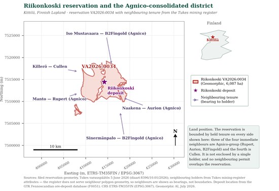
Figure 1: Riikonkoski reservation VA2026:0034 in the Central Lapland district. Neighbouring positions are shown as bearings to tenure holders because the Tukes register source used for the map did not serve neighbouring polygon geometry. The named neighbouring properties are third-party ground. Sources: Tukes mining register and reservation decision; GTK Fennoscandian ore-deposit database.
To view an enhanced version of this graphic, please visit:
https://images.newsfilecorp.com/files/12557/310635_9f70dc6434a91b01_001full.jpg
WHAT THE NEW COMPILATION ADDS
The recovered database changes the Project from a collection of historical headline intervals into a testable geological model. The dense copper assay coverage provides the architecture for a gold programme, while the sparse gold coverage identifies exactly where the archive remains open. The highest-grade gold samples fall into two chemically distinct groups, supporting the possibility of more than one gold-bearing pulse within the copper system; notably, they lack the antimony and tungsten pathfinder signature that characterises the refractory orogenic gold mined elsewhere in the district. No metallurgical testwork exists and no recovery claim is made.
The depth case is concentrated at East Ore, the smaller and higher-grade of the historical copper zones. GTK's own reporting recorded East Ore as closed downward only at its northern end. Between the shallow high-grade gold in R-352 and the deep gold in R-330 lies roughly 160 vertical metres through which only 9 m of core has ever been assayed for gold. That interval is unassayed, not tested and barren - the single clearest illustration of what a copper-only sampling programme did to this Project.
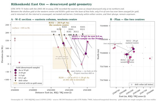
Figure 2: Historic gold sample geometry at East Ore, drawn from recovered collar and downhole-survey records. Gold values shown are single stored-core samples and not true widths. The high-grade centres and the interpreted open-below geometry are exploration hypotheses; continuity and plunge have not been demonstrated, and hole traces are a screening-level approximation. Source: recovered GTK drillhole database and 2005-06 re-assays.
To view an enhanced version of this graphic, please visit:
https://images.newsfilecorp.com/files/12557/310635_9f70dc6434a91b01_002full.jpg
JOINT VENTURE OR SALE
Geomorphic has assembled a partner-ready data room comprising the recovered drillhole database, historic GTK reports and logs, Taranis public disclosures, the reconstructed hole traces, tenure and environmental geometry, and the Nälkävaara surface archive. The lowest-cost first phase is verification-led: obtain and re-sample the R-328 and R-312 stored-core intervals using methods suitable for coarse gold; systematically sample the untested copper and logged sulphide intervals for gold and a complete pathfinder suite; and add the Nälkävaara trench and percussion archive to the same programme. Oriented drilling would then test the East Ore continuation below the historic holes. The Company will consider a joint venture, earn-in or sale.
For joint-venture, earn-in and acquisition enquiries: Jeff Phillips, VP Business Development | [email protected]
ABOUT GEOMORPHIC AI
Geomorphic AI is a prospect generator. Using systematic, data-driven screening of geological databases and historic datasets, the Company identifies overlooked mineral systems in Tier-1 jurisdictions, secures the ground, and compiles partner-ready exploration packages. Geomorphic advances projects through joint ventures, earn-in agreements, sales and other partnerships with operating companies that fund and execute exploration, while Geomorphic may retain a continuing interest.
TECHNICAL NOTES
The exploration results in this release are historical in nature and are drawn principally from GTK Mineral Deposit reports 469, 715, 127 and 126; GTK Hakku archive reports 4219 and 9868; the 2013 relinquishment report for claims Riikonkoski 1-3 (reg. 7968/1-3) and its accompanying drillhole database and per-hole logs; Taranis Resources' release dated August 5, 2011; and GTK report M19/2734/-78/1/10 for Nälkävaara. This information has not been independently verified by the Company, and no Qualified Person has undertaken sufficient work to verify it or to classify the historical estimates as current Mineral Resources. No current Mineral Resource or Mineral Reserve exists for the Project, none is implied, and no tonnage, grade or contained-metal exploration target is stated or intended.
The approximately 9.5 Mt at about 0.48% Cu total and its component estimates are non-compliant GTK estimates prepared under 1970s conventions and reported as asset history only. It is the sum of the three zones GTK considered reliably estimated; including the two smaller zones GTK flagged as less reliable, the five-zone total is approximately 9.8 Mt at about 0.48% Cu. The West Ore zone, which accounts for most of that historical tonnage, lies largely beneath the protected Ounasjoki channel, a Natura 2000 site, and is not presented as an accessible exploration or development asset. The approximately 74% figure is the share of gold grade-metres, at a 1 g/t cut-off, from gold samples in the recovered database whose reconstructed positions fall inside the reservation and outside the Natura 2000 boundary; by sample count the equivalent figure is lower. It is a sample-based screening proxy computed from reconstructed hole traces, not a block model, a resource estimate or a permitting conclusion.
Taranis reported the 2011 composites as approximate true thickness, but the underlying certificates, from-to intervals and compositing rules have not been recovered. The R-328 result has not been reproduced by a second laboratory; the other recovered gold assays in R-328 lie outside the inferred composite interval and therefore do not verify or contradict it. The R-312 composite is dominated by one 0.9 m INAA sample grading 39.0 g/t Au and is not evidence of six metres of continuous high-grade gold. Single high-grade samples are selective and subject to a strong nugget effect. Gold and copper were commonly analysed in different campaigns; enclosing copper grades and the 19-of-22 pairing are depth matches from the recovered database, not same-pulp determinations, and exclude one hole whose archived record could not be reconciled against the original scanned assay log. Reported widths are as disclosed by the historical source; true widths are otherwise unknown.
At Nälkävaara, the best reported boulder assayed 0.90% Cu and 0.0 g/t Au at 1978 reporting precision. That was the only reported gold determination from the swarm. The sixteen reported trench samples and 174 percussion points were not analysed for gold, and the site's gold potential is therefore untested rather than demonstrated. Surface and boulder samples are selective by nature and may not represent the grade or width of an underlying mineralised zone.
No metallurgical testwork has been completed on Riikonkoski. References to chemically distinct gold populations and to pathfinder-element signatures describe limited historical geochemistry on a small number of samples and do not establish mineralogy, recovery characteristics or processing performance. Reconstructed hole traces are a screening-level approximation derived from recovered collar and survey records and are not resource geometry; reconstructions of individual hole positions differ between methods. The interpreted gold centres, extensions and structural relationships require confirmation by oriented drilling and systematic re-assay.
Reservation VA2026:0034 was granted by Tukes on June 5, 2026 for a term ending May 12, 2028. A Finnish mineral reservation (varaus) confers priority to apply for an exploration permit; it does not authorise exploration, land access, drilling or mining. Any field programme requires the applicable exploration permit, landowner arrangements, environmental screening and other approvals. The Agnico Eagle properties, Kittilä mine and mill, and all other third-party properties referred to in this release are not owned by Geomorphic, and their location, ownership, resources, infrastructure and results are not indicative of any result at Riikonkoski. Readers are cautioned not to place undue reliance on historical data.
CONTACT
For joint-venture, earn-in and acquisition enquiries: Jeff Phillips, VP Business Development | [email protected]
FORWARD-LOOKING STATEMENTS
This release contains forward-looking statements subject to risks and uncertainties, including exploration-permit, environmental-review and land-access timing; the availability and condition of archived core, pulps and records; re-assay, geophysical and drilling results; the interpretation and continuity of historical mineralisation; the relevance of nearby infrastructure and third-party properties; commodity prices; transaction outcomes; and future exploration results. Actual results may differ materially. Forward-looking statements are made as of the date of this release, and readers should not place undue reliance on them.
To view the source version of this press release, please visit https://www.newsfilecorp.com/release/310635
